aprs
[ Пред. ] [ Содержание ] [ След. ]
aprs
Created Вторник 06 Февраль 2018
Maps
https://aprs.fi
https://www.aprsdirect.com
APRS и Orange PI
https://vladikoms.livejournal.com/87373.html
Правила работы в APRS
Протокол APRS развивается и улучшается. Согласно спецификации APRS 1.01 и дополнениям APRS 1.1 от 2004 года и APRS 1.2, есть чёткие правила которые нужно соблюдать. Остановимся на некоторых:
Дополнительный идентификатор к позывному (SSID), который даёт некоторое представление о том что это за станция, нужно указывать согласно следующим рекомендациям:
-1 любые станции (дигипитеры, мобильные, WX и так далее)
-2 любые станции (дигипитеры, мобильные, WX и так далее)
-3 любые станции (дигипитеры, мобильные, WX и так далее)
-4 любые станции (дигипитеры, мобильные, WX и так далее)
-5 для устройств типа Dstar, Iphones, Androids, Blackberry's и тд.
-6 специальные мероприятия (спутники, мкс, походы, 50мгц и тд)
-7 носимые станции (когда станция в руках у человека)
-8 лодки, парусники (возможно как второй SSID для мобильного применения)
-9 мобильное применение, путешествия (основной)
-10 internet, Igates, echolink, winlink, AVRS, APRN и так далее
-11 воздушный шар, самолёт, космический корабль
-12 APRStt, DTMF, RFID, треккеры и другие устройства только излучающие сигнал
-13 станции погоды (WX) метеостанции
-14 водители грузовиков
-15 любые станции (дигипитеры, мобильные, WX и так далее)
| SSID | Description |
|---|---|
| -0 | Your primary station usually fixed and message capable |
| -1 | Generic additional station, digi, mobile, wx, etc |
| -2 | Generic additional station, digi, mobile, wx, etc |
| -3 | Generic additional station, digi, mobile, wx, etc |
| -4 | Generic additional station, digi, mobile, wx, etc |
| -5 | Other networks (Dstar, Iphones, Androids, Blackberry's etc) |
| -6 | Special activity, Satellite ops, camping or 6 meters, etc |
| -7 | Walkie talkies, HT's or other human portable |
| -8 | Boats, sailboats, RV's or second main mobile |
| -9 | Primary Mobile (usually message capable) |
| -10 | Internet, Igates, echolink, winlink, AVRS, APRN, etc |
| -11 | Balloons, aircraft, spacecraft, etc |
| -12 | APRStt, DTMF, RFID, devices, one-way trackers*, etc |
| -13 | Weather stations |
| -14 | Truckers or generally full time drivers |
| -15 | Generic additional station, digi, mobile, wx, etc |
Цель (destination) маяка, нужно указывать GPSxx где xx это номер вашего региона. Например, если aprs-станция в Ставропольском крае, нужно использовать GPS26, в Карачаево-Черкессии GPS09 и так далее.
http://info.aprs.net/index.php?title=Frequencies
Primary VHF Networks
North America: 144.390 MHz (Voice Alert 100.0 Hz CTCSS, mobiles only please!)
Europe: 144.800 MHz (Voice Alert 136.5 Hz CTCSS)
Russia: 144.800 MHz
Australia: 145.175 MHz (Voice Alert 91.5 Hz CTCSS)
New Zealand: 144.575 MHz
Argentina: 144.930 MHz
Uruguay: 144.930 MHz (145.010 MHz also)
Japan: 144.640 MHz 9600 baud / 144.660MHz 1200 baud
South Africa: 144.800 Mhz
Alternative Input VHF Networks
For low-powered trackers only:
Many areas: 144.99 MHz
Western Washington State: 144.35 MHz
UHF Networks
Europe / Africa (IARU region 1):
Primary 433.800 MHz (heavy ISM interference in many countries)
Secondary 432.500 MHz since 2008 where ISM is too bad on 433.800 (CT08_C5_Rec32)
Australia (VK): 439.100 MHz 1200 baud (in selected areas)
Netherlands (PA): 430.5125 MHz 1200 baud
Puget Sound, WA: 440.800 MHz 9600 baud
Kansas / Missouri: 446.175 MHz 1200 baud (primary, with infrastructure)
Kansas / Missouri: 441.175 MHz 1200 baud (secondary / special event, no infrastructure)
US Nationwide Proposed: 445.925 (proposed by Bob WB4APR)
New Zealand (ZL): 432.575 MHz 1200 baud allocated but little usage
Six Meters
United States (IARU region 2):
Primary Meteor Scatter: 50.660MHz 9600 baud
Secondary Meteor Scatter: 50.680MHz 1200 baud
Washington, DC: 50.620MHz 1200 baud (shared with PropNet)
Alabama: 50.640MHz 9600 baud
HF Frequencies
Dial frequencies based on default tones used in popular packet devices.
30 meters, 300 baud packet, Worldwide
USB Dial Frequency Mark Frequency LSB Dial Frequency
KAM, MFJ, TinyTrak 10.147.600 MHz 10.149.200 MHz 10.151.000 MHz
AEA 10.147.100 MHz 10.149.200 MHz 10.151.500 MHz
HF FREQS: MARK MFJ/KAMS AEA'S Mode NORMAL USAGE
10.149.2 10.151 10.1515 LSB National HF tracking freq
7.083.2 7.085 7.0855 LSB Regional HF tracking nets
14.098.2 14.100 14.1005 LSB Recommended DX tracking freq
14.103.2 14.105 14.1055 LSB Packet Keyboarding freq
28.187 1200 baud LSB FEED Channels every 2 KHz
Satellites
ISS 145.825 MHz 145.825 MHz ARISS 1200 baud AFSK packet Active
PCSAT-2 145.825 MHz 435.275 MHz ARISS or WIDE2-2 1200 baud AFSK packet Active
PCSAT-1 (NO-44) 145.825 MHz 145.825 MHz ARISS 1200 baud AFSK packet Daylight Ops Only
На каких же частотах работают станции в PSK31-APRS. Такие станции были зафиксированы на (частота тона обычно 1500Гц) :
10142.450 USB
14071 USB
14095 USB
18100.450
28131 USB
50291 USB
144.131 USB
Packet parsing
https://aprs-python.readthedocs.io/en/latest/parse_formats.html#telemetry-configuration
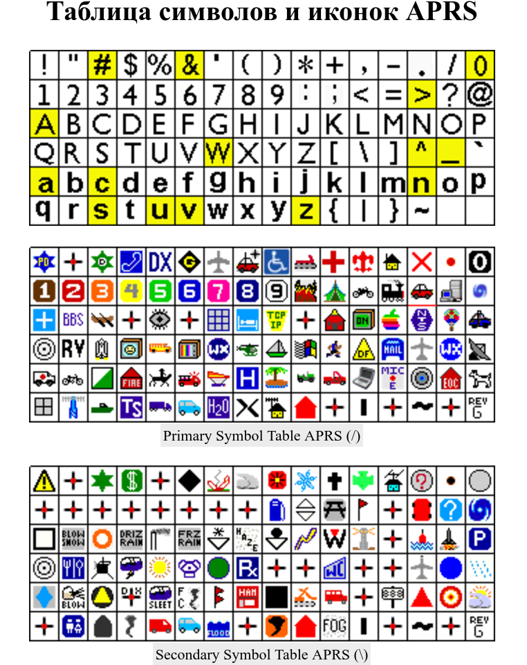
Вложения:
| нажми сюда | нажми сюда | нажми сюда |
|---|---|---|
| symbols.png | 282kb |
М <0xd0><0x9c>
и <0xd0><0xb8>
р <0xd1><0x80>
Т <0xd0><0xa2>
р <0xd1><0x80>
у <0xd1><0x83>
д <0xd0><0xb4>
М <0xd0><0x9c>
а <0xd0><0xb0>
й <0xd0><0xb9>
<0xd0><0x9c><0xd0><0xb8><0xd1><0x80><0x21> <0xd0><0xa2><0xd1><0x80><0xd1><0x83><0xd0><0xb4><0x21> <0xd0><0x9c><0xd0><0xb0><0xd0><0xb9><0x21>
APRS List of HF freqency offsets for the global APRS HF frequencies.
Virtual Carrier Audio Frequencies
7034.30 10149.30 Mark Space
Bell 103 Orig LSB 7035.47 10150.47 1070 1270
Bell 103 Orig USB 7033.13 10148.13 1070 1270
Tig TM1 LSB 7035.50 10150.50 1100 1300
Tig TM1 USB 7033.10 10148.10 1100 1300
MFJ1270 LSB 7036.00 10151.00 1600 1800
MFJ1270 USB 7032.60 10147.60 1600 1800
KamPlus LSB 7036.00 10151.00 1600 1800
KamPlus USB 7032.60 10147.60 1600 1800
Bell 103 Answ LSB 7036.43 10151.43 2025 2225
Bell 103 Answ USB 7032.18 10147.18 2025 2225
MFJ1278 LSB 7036.50 10151.50 2100 2300
MFJ1278 USB 7032.10 10147.10 2100 2300
PK232 LSB 7036.51 10151.51 2110 2310
PK232 USB 7032.09 10147.09 2110 2310
DSP-12 LSB 7036.53 10151.53 2125 2325
DSP-12 USB 7032.08 10147.08 2125 2325
NEW OPTIONS EDITION APRS 1.2 -------------------------------------------------------------------------------
APRS version 1.2.1 WEATHER UPDATES TO THE SPEC 24 Mar 2011
-------------------------------------------------------------------
24 Mar 2011 Proposed major simplification of new sensor approach
23 Mar 2011 updated Radiation Reporting Field
6 Jan 2010 previous version
After the Japanese Nuclear incident in Mar 2011, we realized we
needed a radiation sensor field in the APRS weather format. But in
2006 we had already added Flood gages and Flooding symbols.
Apparently on Firenet where these water gage symbols appear, they
are all not using the weather format but are using this format:
;09428508 *061713z3401.40N/11424.75Ww3.57gh/82cfs
This March 2011 we have proposed a change to simplify new sensors
as follows:
1) All weather data (and any new sensor data) will be transmitted
using one of the existing WX parsable symbols: *_, where "*"
is now used as a wildcard meaning any of the table characters or
overlays.
2) All HAZARD symbol categories will also be parsed for weather
and other sensor formatted data. This is because, once a condition
has exceeded a threshold, that station/sensor can change its
symbol to indicate that HAZARDOUS condition. So this includes *H
symbols.
3) The 2006 Water gage format noted above will not change, since it
has no impact on the weather sensor format. The 2006 proposal for
water gages did include a format for inclusion in weather data, and
that format is still valid, but will ONLY be parsed for in otherwise
valid weather data formats. The special water gage and flooding
symbols /w and \w introduced in 2006 will not be parsed for weather
data as originally proposed.
Changes implicated by the above will be updated in all APRS files
that I can find. Such as:
http://aprs.org/aprs11/symbols.txt
http://aprs.org/aprs12/watergage.txt
Readers should also review all the clarifications to
the original spec made in the APRS1.1 addendum in this document:
http://aprs.org/aprs11/spec-wx.txt
This new aprs12/weather-new.txt file will contain all proposed
APRS1.2 additions to the WX format fields. For the full APRS1.2
addendum, see http://aprs.org/aprs12.html
COMPLETE REPORT: The use of the COMPLETE APRS weather format is
strongly encouraged where both position and weather data are included
in a single COMPLETE packet. The use of the positionless weather
format is strongly discouraged since it is useless without position,
and the requirement for additional weather station position report
packets are equally useless without weather included in them! It is
an anathma for a real time system such as APRS to split this data
among multiple unreliable packets.
RADIATION LEVEL: The field Xxxx has been proposed for reporting the
level of Nuclear Radiation levels if available. The X is the type
indicator. We chose "X" for radiation. The xxx are like the resistor
code. First, two digits of precision and the last digit is the order
of magnitude in NANOSEVERTS/Hr. So 123 is 12 * 10^3 nanosieverts/hr or
12 microsieverts/hr. Or 456 is 45 * 10^6 nanosieverts/hr or 45
millisieverts/hr. One bananna generates about .1 uSieverts/hr,
a Brazil nut .4 uS/hr.
If the radiation is at background levels the /_ weather symbol may be
used, when elevated readings occur, the R_ weather symbol with "R"
overlay will indicate a Radiation Sensor weather station. When a
hazard threshold has been reached, the symbol can change to a RH
symbol (Hazard with R overlay).
WATER GAUGE INFO:
In June 06, water level gage info was added to APRS. Two new
symbols were introduced, one for H2O "/w" and the other for FLOOD "\w".
The device can choose to send either of these symbols depending on its
own threshold for "flooding". The data format for these objects
appears to be:
;09428508 *061713z3401.40N/11424.75Ww3.57gh/82cfs
Which is standard Object format with a text of "3.57gh/82cfs" meaning
gage height and cubic feet per second.
NEW: We propose that water gage readings can also be included in
weather reports. For benign water readings included with WX info
use the normal /_ weather symbol, unless the flood gage reading is
important when the F_ weather station with F overlay will be used.
When FLOOD conditions are reached, the symbol can change to a hazard
symbol (FH).
The height above or below flood or tide level in inches is included in
the position comment string as Fxxxx and that string is chosen to be
compatible with the standard APRS weather reporting parameters. In
addition, a voltage field Vvvv is also added. Thus, the usual APRS
weather report string similar to:
DIR/SPD/Gggg/Tttt/Rrrr/Pppp etc
is extended by adding these additional parameters for
Fxxxx water level above or below flood stage or mean tide in tenths
of a foot. Values can range between +999 and -999 in tenths
meaning -99.9 to +99.9 feet. Meters are not used for the on
air format because it gives too little or too much resolution
to fit in the fixed length 4 bytes that are required.
Vxxx battery volts in tenths 128 would mean 12.8 volts
Zxx Device type
These fields can either be added to a WX station report where the WX
symbol would continue to be used, or the available weather data can
be added to a Water Gage report using either of the two water symbols.
The standard WX report allows for any field to be indicated as not
available either by omission or by replacing the value with "...".
SInce the wind direction and speed and temperature are required fields,
this means the minimum weather report with flood info is
WX symbol -plus- .../...t...VxxxFxxxx
or the minimum water gauge report is
Water symbol -plus- VxxxFxxxx/ZFA
Notice that if water data is added to a WX report, then only Fxxxx
and optional Vxxx are added to the WX report. But if WX data is
added to a water gage report, then the minimum fields of wind
direction and speed and temperature .../...t...Fxxxx are required.
Examples are:
Weather Station reports with flood gage readings:
DDMM.hhN/DDDMM.hhW_ddd/sss/Gggg/Tttt/Fxxxx...
DDMM.hhN/DDDMM.hhW_ddd/sss/Gggg/Tttt/Fxxxx/Vvvv...
DDMM.hhN/DDDMM.hhW_ddd/sss/Gggg/Tttt/Rrrr/PppppFxxxx...
Water Gage Object reports (w/o weather):
;09428508 *061713z3401.40N/11424.75Ww3.57gh/82cfs
Water Gage Object reports with weather:
DDMM.hhN/DDDMM.hhWwFxxxx/ZFA
DDMM.hhN/DDDMM.hhWwFxxxxVvvv/ZFA
DDMM.hhN\DDDMM.hhWwFxxxxVvvv/ZFA
DDMM.hhN/DDDMM.hhWwddd/sss/Gggg/Tttt/Fxxxx/ZFA
DDMM.hhN/DDDMM.hhWwddd/sss/Gggg/Tttt/FxxxxVvvv/ZFA
DDMM.hhN\DDDMM.hhWwddd/sss/Gggg/Tttt/FxxxxVvvv/ZFA
Water Gage reports (new):
DDMM.hhNFDDDMM.hhW_Fxxxx/ZFA
DDMM.hhNFDDDMM.hhW_FxxxxVvvv/ZFA
DDMM.hhNFDDDMM.hhW_FxxxxVvvv/ZFA
DDMM.hhNFDDDMM.hhW_ddd/sss/Gggg/Tttt/Fxxxx/ZFA
DDMM.hhNFDDDMM.hhW_ddd/sss/Gggg/Tttt/FxxxxVvvv/ZFA
DDMM.hhNFDDDMM.hhW_ddd/sss/Gggg/Tttt/FxxxxVvvv/ZFA
Flood Hazards(new):
DDMM.hhNFDDDMM.hhWHFxxxx/ZFA
DDMM.hhNFDDDMM.hhWHFxxxxVvvv/ZFA
DDMM.hhNFDDDMM.hhWHFxxxxVvvv/ZFA
DDMM.hhNFDDDMM.hhWHddd/sss/Gggg/Tttt/Fxxxx/ZFA
DDMM.hhNFDDDMM.hhWHddd/sss/Gggg/Tttt/FxxxxVvvv/ZFA
DDMM.hhNFDDDMM.hhWHddd/sss/Gggg/Tttt/FxxxxVvvv/ZFA
Notice that since 2006, existing software had to also consider parsing
the appearance of any WATER or FLOOD symbols to see if they also
include Weather. Also, everyone's weather parser needed to look
at the WX fields for the optional additional Fxxxx or Vvvv fields.
This has been simplilfied in addendum 1.2.1 so that only two APRS
symbol groups need to be parsed for Weahter and other sensor data,
that is the original *_ and *W for weather plus the new *H hazards.
Parsing the old water gage data may be required until all legacy
water gages are gone.? Comments?
de WB4APR, Bob ---------------------------------------------------------------------------------------------------
